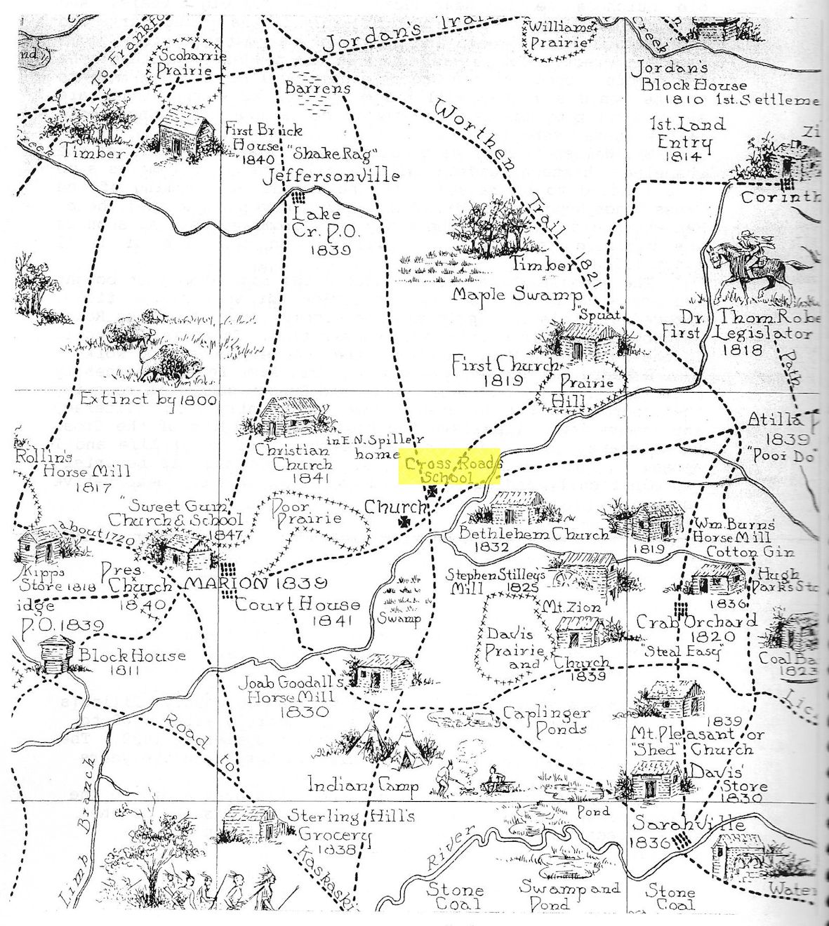
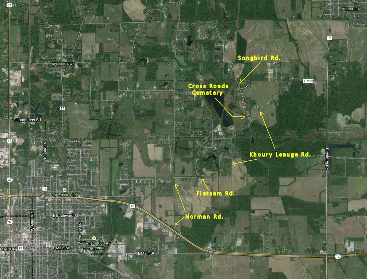
Cross Roads – Where did it get the name?
 The answer, I think. Is a very simple one, the roads cross here.
The information contained in this report is from my personal knowledge, observations, and from conversations with older people who lived in the area.
I have been told that the name was first given to the church because of the roads crossing near the church. The church was located a half mile west and south of the present Cross Roads community center.
I am familiar with the road which ran from the present road along the top of the ridge northwestward to the church, but I have never seen or heard of the roads crossing at this point. This is approximately one half mile of the original trail that was the main route to the west.
The actual crossroads from pioneer times was very close to the present day cross roads. The road ran from the southeast to the northwest. This route was the main passage from crossings of the Ohio River to the northwest.
 According to my great aunt Margaret Swafford Pulley, her father and his five boys used this trail in traveling from western Tennessee to the Kansas Territory.
Each year when they had their planting done at their home in Tennessee, they rigged up a covered wagon, packed a month’s supplies of groceries, ham sides (bacon), and an extra blue shirt and a pair of overalls for each boy. Then they would travel to Kansas, where they would all work in the Kansas wheat harvest.
On the trek westward, they crossed the Ohio River on a raft kind of boat near Rosiclare, and traveled northwestward. They crossed the Saline Creek at Sarahville, which is some four miles south of Crab Orchard. I have never heard any account of why it was named Sarahville, I presume a lady by the name of Sarah must have lived close by and may have operated a small general store there.
When I was 5 or 6 years old, we would ride in the wagon with my father to the Ferrel orchards or to Creal springs. He had to cross saline Creek on the Sarahville Bridge. It was a big bridge and high over the water. Our mules were scared to death of that bridge. We boys had to walk across the bridge in case the mules pushed the wagon and all, over the side and into the creek some 30 feet below.
After crossing Saline creek, they traveled north to the old Mare Coonce place. From there west on the Shed Church Road which was called the Old Lick Road. From there through the Old Bethlehem Road, crossed the Crab Orchard creek just north of the Bethlehem cemetery which is about half a mile north of Mason and Bill Absher’s place now (on new route 13 between Moeller Crossroads and Marion).
Continuing northwest across what was later known as the Old Davis Place and crossing the Marion-Corinth Road at about the same place the roads cross now.
At this time there was no state route 166. All the traffic from Marion to Halfway, Corinth, and Jordan’s Store all used this trail.
So you can see that these two roads played a great part in the settlement of the territory.
One summer when my great grandfather and his boys were working in Kansas, the wheat harvest lasted longer than they had anticipated. It was late in the fall before they left Kansas for their home back In Tennessee. On this trip home they had gotten to the Old Lick Road. It had rained, the roads were muddy and their horses were about given out. They came to an old house on the side of the road about an eighth of a mile west of where the Shed church now stands. Since there was no one living in the old house and it seemed deserted, they camped there to let the horses rest before continuing on home.
Some neighbor spotted the covered wagon and when it didn’t leave right straight, he went over to Mr. George Knoboloch to tell him there were Gypsies camped at his old farm house and that he might want to see about them.
Gypsies were noted for stealing everything along the countryside, and even kidnapping children. This was one of our dreaded fears when I grew up. My mother always told us boys when we saw Gypsies coming, to run home as fast as we could, lest we get kidnapped by the Gypsies and carried to a far off place, even to Oklahoma.
Mr. Knoboloch like about Ben Adam whose exceeding peace had made him bold, went to Investigate the Gypsies camped on his land.
When my great, great grandfather told him that their horses had given out and they had to rest them for a while and they meant no harm to anyone. Mr. Knoboloch, being the gracious old German that he was, let them stay as long as they needed to. He even offered the boys a job clearing land at 15-20 cents per day while their horses rested and got enough strength to continue on home.
The boys enjoyed the work and the pay so well that they stayed the rest of the winter and spring clearing the land and putting out the crop. This is the story of how my mother’s family got to Southern Illinois.
The next I knew of the Swafford family, they were living In Cross Roads district and working for Mr. George Spitznass.
The Swafford family lived in this district for some time because my mother attended Cross Roads when she was in the 4th and 5th grade. I can imagine how excited and enthused she must have been, trying to discover all the mysteries of life.
(Written by Leslie Stilley, a Cross Roads teacher in 1928-31, Published in Cross Roads School by Bob Jackson, published in 1984, for sale at the Williamson County Historical Society Book Store)